100 Best 「atlas」 Books of 2025| Books Explorer
- National Geographic Student World Atlas, 6th Edition
- Atlas Obscura, 2nd Edition: An Explorer's Guide to the World's Hidden Wonders
- Brilliant Maps: An Atlas for Curious Minds
- National Geographic Concise Atlas of the World, 5th edition: Authoritative and complete, with more than 200 maps and illustrations
- National Geographic Family Reference Atlas 5th Edition (National Geographic Family Reference Atlas of the World)
- National Geographic Atlas of the World, 11th Edition
- World Atlas of Beer: The Essential Guide to the Beers of the World
- Children's Illustrated Atlas: Revised and Updated Edition
- The World Atlas of Coffee: From Beans to Brewing - Coffees Explored, Explained and Enjoyed
- The World Atlas of Wine 8th Edition

From the map experts at National Geographic comes the sixth edition of the award-winning Student World Atlas―the best resource ever for middle and high school students to become informed global citizens.This latest edition, created with the help of a geography educator, has everything kids want and need to know about our changing world. Dynamic, user-friendly content includes stunning photos, fascinating facts, charts, graphics, and full-color political, physical, and thematic maps on important topics. This edition includes:•New thematic maps for every continent•New and updated infographics•Updated maps and statisticsWhether it’s used in the classroom, for college prep, or for exploring at home, this atlas will introduce readers to places, people, and issues in their own country and across the planet.For younger readers, don’t miss the National Geographic Kids World Atlas (6th edition) and the National Geographic Kids Beginner’s World Atlas (5th edition)!

Discover wonder.“A wanderlust-whetting cabinet of curiosities on paper.”— New York TimesInspiring equal parts wonder and wanderlust, Atlas Obscura is a phenomenon of a travel book that shot to the top of bestseller lists when it was first published and changed the way we think about the world, expanding our sense of how strange and marvelous it really is.This second edition takes readers to even more curious and unusual destinations, with more than 100 new places, dozens and dozens of new photographs, and two very special features: twelve city guides, covering Berlin, Budapest, Buenos Aires, Cairo, London, Los Angeles, Mexico City, Moscow, New York City, Paris, Shanghai, and Tokyo. Plus a foldout map with a dream itinerary for the ultimate around-the-world road trip. More a cabinet of curiosities than traditional guidebook, Atlas Obscura revels in the unexpected, the overlooked, the bizarre, and the mysterious. Here are natural wonders, like the dazzling glowworm caves in New Zealand, or a baobob tree in South Africa so large it has a pub inside where 15 people can sit and drink comfortably. Architectural marvels, including the M. C. Escher–like stepwells in India. Mind-boggling events, like the Baby-Jumping Festival in Spain—and no, it’s not the babies doing the jumping, but masked men dressed as devils who vault over rows of squirming infants.Every page gets to the very core of why humans want to travel in the first place: to be delighted and disoriented, uprooted from the familiar and amazed by the new. With its compelling descriptions, hundreds of photographs, surprising charts, maps for every region of the world, and new city guides, it is a book you can open anywhere and be transported. But proceed with caution: It’s almost impossible not to turn to the next entry, and the next, and the next.

Which nations have North Korean embassies? Which region has the highest number of death metal bands per capita? How many countries have bigger economies than California? Who drives on the 'wrong' side of the road? And where can you find lions in the wild? Revelatory, thought-provoking and fun, Brilliant Maps is a unique atlas of culture, history, politics and miscellanea, compiled by the editor of the iconic Brilliant Maps website. As visually arresting as Information is Beautiful and as full of surprising facts and figures as any encyclopaedia, Brilliant Maps is a stunning piece of cartography that maps our curious and varied planet. For graphic design enthusiasts, compulsive Wikipedia readers and those looking for the sort of gift they buy for someone else and wind up keeping for themselves, this book will change the way you see the world and your place in it.

With more than 250 maps, graphics, and illustrations, the National Geographic Concise Atlas of the World offers an authoritative and engaging portrayal of the world and all that is in it.Expert, up-to-date maps of the world, every continent, and the United States include physical and political details and boundaries, key data for each continent, plus flags and facts for every country, enhanced with representative photographs portraying themes and regions. Additionally, maps and data-based graphics visualize the timely issues of our day, such as population trends, climatic conditions, health, and economics. A special section on space includes maps of Earth’s moon and Mars, as well as diagrams of the solar system, the universe, and exploratory missions. Large-format pages allow for copious detail; a sturdy softcover format promises a long shelf life; and a comprehensive place-name index enables quick and easy searches.This newest edition of the Concise Atlas of the World brings National Geographic’s award-winning cartography into everyone’s reach.

Show your kids the world with fascinating facts and more than 650 photographs, maps, and graphics covering every country--plus the poles, the oceans, and outer space--in this completely revised edition of National Geographic's beloved family-oriented atlas.This exquisitely updated edition of National Geographic's popular and reader-friendly Family Reference Atlas features authoritative maps, detailed artwork, and explanatory graphics--an indispensable source of information for inquiring minds, young and old. In these richly illustrated pages, every country in the world is represented by a detailed map within its geographical context and also its flag, key statistics, and secondary maps with environmental and population information. Special sections feature maps and facts about the ocean, the solar system, and the universe beyond. Newsworthy topics from climate change and human migration to languages and digital connectivity are explained in maps, graphics, and photos. Fully indexed, and written to engage all ages, this indispensable atlas belongs in every family library.

Created for all global citizens, this universally respected volume of world maps has been completely revised and updated with fascinating visualizations of international trends and global conditions.National Geographic's flagship Atlas of the World, now in its 11th edition, provides authoritative maps of every country, ocean, and region of the world, as well as thematic maps and accompanying graphics showing important population, environmental, and economic patterns. Organized by continent and reflecting today's political boundaries and identities, this authoritative atlas is an indispensable reference for schools and libraries, as well as the latest resource for home browsing and study. A thematically organized opening section uses current data to visualize urgent concerns, such as Earth's last wild places, changing freshwater availability, human migration and refugee movement, and human rights conditions globally. The back of the book contains basic facts and flags of every country, as well as a comprehensive index cross-referencing more than 150,000 place names. A thought-provoking foreword by Alexander M. Tait, The Geographer of National Geographic, begins the book.

The definitive guide to world beer fully updated for a third editionAs craft brewing continues to go from strength to strength across the world, World Atlas of Beer is the definitive and essential guide to beer. Understand the rich, multi-faceted traditions of Belgium, the Nordic legend that is Finnish Sahti, the relatively new phenomenon of the New England hazy IPA, and why Australia's lower-strength beers are one of its great successes. With thousands of breweries now operating around the globe, and more opening every day, this is the expert guide to what is really worth drinking.Country by country the book considers a vast range of brewing techniques, beer styles and traditions. Detailed maps describe crucial trends in major territories and features such as matching beer with food and how to pour different kinds of beer complete the picture.Now in a fully updated third edition, this book is the perfect companion to help you explore the best beers the world has to offer.Praise for the second edition of World Atlas of Beer:'Written with authority and wit... the perfect guide to the rapidly changing beer scene' - the Guardian

Set off on a thrilling journey around the world in this incredible atlas for kids – packed full of beautiful illustrations and photographs.Discover the world map-by-map with this exciting world atlas book for children, featuring more than 50 maps! Each page is filled with fascinating information, facts and colorful illustrations of our world.Children aged 7-9 will love to learn all about the many countries, cultures, people and animals of the world through vibrant maps. Each map is bursting with information, combining colorful icons with photographs representing key points about each country. The atlas also includes a world map poster, with a political map for each continent - and children are shown how to read a map and use a key, compass, and scale!Inside the pages of this atlas book for children, you’ll find:- Information that supports the curriculum, with colorful icons and photographs that show people and places, animals, food, historical sites, industry, and habitats.- More than 50 specially commissioned maps of the world featuring countries and continents in full-color detail.- Bite-sized facts and figures about each country making it easy for children to understand.- Diagrams that compare climates, population, mountains and rivers, famous sites, and natural wonders of the world.Children’s Illustrated Atlas brings the world to life with vivid maps and fascinating facts about the countries of the world, making it the perfect gift for little geographers. This charming and informative book is a key addition to every child’s library.

The bestselling reference updated and expanded with seven new coffee-growing countries.Praise for the first edition:"Fills a gap in the popular reference literature. Recommended."-- Booklist"The definitive guide.... Well-written, informative, and a must-have for general readers who want to know more about their favorite morning brew."-- Publishers Weekly"Educational, thought-provoking, and substantial. I've already recommended this book to (our) readers countless times."-- Barista MagazineThe World Atlas of Coffee takes readers on a global tour of coffee-growing countries, presenting the bean in full-color photographs and concise, informative text. It covers where coffee is grown, the people who grow it and the cultures in which it is a way of life. It also covers the world of consumption -- processing, grades, the consumer and the modern culture of coffee.For this new edition, the author expanded his research travels over the last several years to include seven additional coffee-growing regions: Democratic Republic of Congo, Uganda, China, Philippines, Thailand, Haiti and Puerto Rico. These are covered in 16 additional pages. As well, all of the book's maps have been updated to show greater detail, and all statistics and data have been updated to the most recent available.Organized by continent and then country or region, The World Atlas of Coffee presents the world's favorite brew in color spreads packed with information.The coverage in The World Atlas of Coffee is wide and deep. The book is used by barista and coffee-tasting instructors in North America and overseas and has been welcomed by enthusiastic coffee drinkers everywhere. Appropriate for special and general collections alike, it is an essential selection.
2020 JAMES BEARD AWARD WINNERJANCIS ROBINSON - 2020 JAMES BEARD COOKBOOK HALL OF FAME HONOREE"The most useful single volume on wine ever published... If I owned only one wine book, it would be this one." - Andrew Jefford, DecanterA major new edition of this landmark wine book that has sold 4.7 million copies worldwide.Few wine books can be called classic, but the first edition of The World Atlas of Wine made publishing history when it appeared in 1971. It is recognized by critics as the essential and most authoritative wine reference work available. This eighth edition will bring readers, both old and new, up to date with the world of wine.To reflect all the changes in the global wine scene over the past six years, the Atlas has grown in size to 416 pages and 22 new maps have been added to the wealth of superb cartography in the book. The text has been given a complete overhaul to address the topics of most vital interest to today's wine-growers and drinkers.With beautiful photography throughout, Hugh Johnson and Jancis Robinson, the world's most respected wine-writing duo, have once again joined forces to create a classic that no wine lover can afford to be without."The World Atlas of Wine is the single most important reference book on the shelf of any wine student." - Eric Asimov, New York Times"Like a good bottle of wine, you'll find yourself going back to it again and again... Perfect for anyone who has a thirst for greater wine knowledge." - Edward Deitch, NBC/today.com"The World Atlas of Wine belongs on your shelf... The essential rootstock of any true wine lover's library. A multi-layered snapshot of wine and how it has evolved." - Dave McIntyre, Washington PostA "masterwork" and a "must-have" - Food & WineWinner Andre Simon Award Best Drinks Book of 2019Shortlisted for the Louis Roederer Wine Book of the Year 2020

This new, fully updated edition of The World Atlas of Whisky provides an in-depth, comprehensive journey through the history, process, distilleries and expressions of world whiskies"The best whisky book ever - a must-read for drinkers!" - Forbes"The perfect go-to reference guide for the whisky lover's bookshelf." - Whisky MagazineAward-winning author and whisky expert Dave Broom explores over 200 distilleries and examines over 400 expressions. Detailed descriptions of the Scottish distilleries can be found here, while Ireland, Japan, the USA, Canada and the rest of the world are given exhaustive coverage. There are tasting notes on single malts from Aberfeldy to Tormore, Yoichi (and coverage of the best of the blends). Six specially created 'Flavor Camp Charts' group whiskies by style and allow readers to identify new whiskies from around the world to try.This extensively updated and extended edition features new material on burgeoning areas, including detailed coverage of many recently opened US craft distilleries, new distilleries in Germany, Austria and Switzerland, and discussion of the growing whisky scene in Latin America.With over 200 beautiful color photographs and 21 color maps locating distilleries and whisky-related sites, this is a stylish celebration of the heritage, romance, craftsmanship and versatility of whisky.

The world has changed and this new atlas from the map experts at National Geographic captures the state of the planet with completely updated maps, stats, and fun facts--the perfect hardcover reference for curious kids and students.Learn all about the people, places, trends, and developments of our world in the fifth edition of this acclaimed atlas. It's got a fresh, kid-friendly design and all the latest, greatest geographic and political information that make this such a valuable resource. New features include a thematic map on endangered species, a map about the region of Central Africa, and an expanded Antarctica section that introduces kids to the important research that is happening there. It's the perfect reference for kids to learn about lands close to home or oceans away--ideal for classroom use, homework help, and armchair exploration.

What would the world be without maps? How would we orientate ourselves? How would we travel How could we plan streets or entire cities? We encounter maps everywhere in everyday life. But they can do much more than just represent the topography of places.The geographer Simon Küstenmacher collects exciting, entertaining and useful maps that open up a new perspective on the world in an extraordinary way. Where on earth do most people live? What does the world look like from a dolphin's point of view? What did the world look like in the 17th century? Where in Europe were the last executions carried out? And how much tip is expected in the different countries?All maps represent our living environment in an unusual way, explain connections from new perspectives and show how much fun data and facts are when they are presented in a visually interesting way.

A new fully updated reference atlas in the exciting Collins world atlas range. Great value and contains all the world maps you need in a budget atlas, for family, study and business use.Explore our planet;• Clear maps giving balanced worldwide coverage• Key statistics and flags for every country of the world• World time zones maps• Discover more than 36,000 placesMapping updates include;• Country name changes – Czechia (formerly Czech Republic),Eswatini (formerly Swaziland) and North Macedonia (formerly Macedonia)• Extensive place name changes in New Zealand, Myanmar and Ukraine• Changes to capital cities in Burundi, Chad, Eswatini, Kazakhstan and Kiribati• Railways in France, Kazakhstan and Turkmenistan. Motorways in UK and Ireland• New rail and road bridge across Kerch Strait• Everest height updated to 8,849m / 29,032ft

A new, fully updated edition of this popular atlas in the stylish and authoritative Collins world atlas range. Designed in the distinctive Collins style, it is the ideal reference atlas for school, home and business use. This is a great value world atlas with more place names (over 80,000) and mapping than any other atlas at this price.

WITH A FOREWORD BY TIM HARFORD Which nations have North Korean embassies? Which region has the highest number of death metal bands per capita? How many countries have bigger economies than California? Who drives on the 'wrong' side of the road? And where can you find lions in the wild? Revelatory, thought-provoking and fun, Brilliant Maps is a unique atlas of culture, history, politics and miscellanea, compiled by the editor of the iconic Brilliant Maps website. As visually arresting as Information is Beautiful and as full of surprising facts and figures as any encyclopaedia, Brilliant Maps is a stunning piece of cartography that maps our curious and varied planet. For graphic design enthusiasts, compulsive Wikipedia readers and those looking for the sort of gift they buy for someone else and wind up keeping for themselves, this book will change the way you see the world and your place in it.

Explore the history of the world in unprecedented detail with this ultimate guide to history throughout the ages.Maps don't just show us where to go, but also where we've been. If you're interested in finding out more about the biggest events in world history, then this book all about history of the world is perfect for you!This stunning history book for adults starts with the evolution and migration of our oldest ancestors out of Africa. You can then look up maps about the Greece and Persian War, the Mongol Conquests, Medieval Europe's trade routes, and the rise of the Ottomans. Explore maps about the colonisation of North America, the scientific revolution, Napoleon's advances, and Britain's control of India. Then uncover the history of later centuries, such as the Age of Imperialism, the American Civil War, industrialised Europe and the transformation of Japan.Journey into past like never before as you uncover:- Easy-to-read text panels for a deeper understanding of history- A total of 140 maps alongside stunning pictures and informative timelines- Storytelling maps to bring history to life- Published in association with the Smithsonian Institution in the USA.Bursting with striking illustrations and full of fascinating detail, this history book is the ultimate gift for map lovers, history enthusiasts of all ages and those who enjoy visiting museums and other historical sites, whether as a present for dad, or handy reference guide for any other history lover in your life! History of the World Map by Map aims to help you gain a strong understanding of some of the forces and movements across continents that have shaped our world!Go on guided tour through time and explore:- Prehistory 7 MYA-3000 BCE- The Ancient World 3000 BCE - 500 CE- Middle Ages 500-1450 CE- The Early Modern World 1450-1700- Revolution and Industry 1700-1850- Progress and Empire 1850-1914- The Modern World 1914-PresentAt DK, we believe in the power of discovery.So why stop there? The Map by Map series includes other titles such as History of the World Map by Map and World War II Map by Map, each detailing historical events and placing them in the context of geography. DK's luxurious Map by Map books are fantastic history gifts, packed with fascinating facts, high-quality photography, and detailed profiles and descriptions of people and events.


Spark our littlest explorers' curiosity about the planet we call home with this fully updated preschool atlas from the map experts at National Geographic.This updated picture atlas ensures that even the youngest explorers have the most current information to help them understand the world. Simple, colorful maps teach kids about Earth's land, water, and countries. Bright, bold pictures and lively, accessible text showcase the world's people, places, and animals. Readers will learn elementary mapping skills and concepts such as the difference between a globe and a map, along with answers to such questions as "What is a continent?" and "Where is the ocean?"Features include:Instructions for how to read and understand a map 4 world maps 7 continent maps United States map Canada map Mexico and Central America map Glossary and pronunciation guide Fun facts sprinkled throughout … and lots more!Little learners will love exploring the great big world with this colorful atlas made just for them!Complete or supplement your atlas collection with the National Geographic Kids Beginner's United States Atlas (4th edition). And for older readers, don't miss the National Geographic Kids World Atlas (6th edition), the National Geographic Kids United States Atlas (7th edition), and the National Geographic Kids Student World Atlas (6th edition).

A singular atlas of 100 infographic maps from thought-provoking to flat-out fun. And don’t miss the next book in the series, North American Maps for Curious Minds! Publisher’s note: Brilliant Maps for Curious Minds was published in the UK under the title Brilliant Maps.Which countries don’t have rivers? Which ones have North Korean embassies? Who drives on the “wrong” side of the road? How many national economies are bigger than California’s? And where can you still find lions in the wild? You’ll learn answers to these questions and many more in Brilliant Maps for Curious Minds. This one-of-a-kind atlas is packed with eye-opening analysis (Which nations have had female leaders?), whimsical insight (Where can’t you find a McDonald’s?), and surprising connections that illuminate the contours of culture, history, and politics.Each of these 100 maps will change the way you see the world―and your place in it. 100 color maps

The only world atlas updated annually, Oxford's Atlas of the World is the most authoritative atlas on the market.Full of crisp, clear cartography of urban areas and natural landscapes around the globe, the Atlas contains maps of cities and regions at carefully selected scales that give a striking view of the Earth's surface.The volume opens with a detailed survey of world statistics, a six-page feature examining energy and environmental impact, and an immersive collection of satellite images of Earth, including stunning new photographs specially sourced and processed for this atlas. The Atlas continues with a Gazetteer of Nations, comprehensively updated to provide a concise overview of the geography, politics, economy, and history of every country in the world. The extensive thematic World Geography section is beautifully illustrated with charts, maps, and graphs on diverse topics of geographic significance, including climate change, biodiversity, population and cities, conflict and cooperation, tourism and travel, global health, wealth, and standards of living. New data covers current topics such as extreme weather events, migration, and the Covid-19 pandemic. The hundreds of city and world maps that form the body of the Atlas have been thoroughly updated for this 29th edition.Providing the finest global coverage available, the Atlas of the World offers a diverse collection of information and cartography of unrivaled accuracy and clarity, presented in an uncommonly beautiful volume.

A beautifully illustrated picture atlas designed to take children on an exciting journey around the world. The atlas opens with the continents, then presents a world view of countries before exploring deeper into each country and the exciting places to visit within each.• The maps are clear, colourful and perfect for children to explore the world and let their imaginations run riot.• Illustrated by Steve Evans.• This book is ideal for home or school and finding out more about the world whilst also helping to develop essential reading skills.• Clear, colourful, highly informative, illustrated mapping designed for young readers.• Arranged by continent for easy reference.• Facts about the world we live in are included on each spread.

Our world as it is today in one beautiful volume. Fully updated mapping with over 200,000 place names. World topics include migration, health and resources.The 16th edition of The Times Comprehensive Atlas of the World has been fully updated. At 45 cm high, this impressive large-scale atlas will become a treasured possession. It is a benchmark of cartographic excellence, trusted by governments, media and international organizations as well as being a trusted reference source for households.

Set sail on an exciting adventure and travel the world with this brightly colored atlas. With over 20 maps, young readers can explore different regions of the world in a series of double page illustrations. Engaging text, fun facts and plenty of features to spot offer a fun-filled introduction to world geography and help build confidence using an atlas. Includes a world map poster for children to practice and play.

Martha LOVES drawing maps. She creates maps of everything-even her thoughts and dreams! Let Martha be your guide as she welcomes you to her world. Starting in outer space, we zoom in page by page, to our planet, Martha's community, and beyond to her dreams of a future where ANYTHING is possible. Full of quirky details and fun non-fiction labels that children will love poring over-they will discover cool new facts with every reading. Each map is imbued with an irresistible sense of excitement about the world and optimism for the future.
Filled with beautiful maps showing our dynamic world in stunning detail, this comprehensive atlas is the perfect choice for anyone interested in the geographyof our planet.First published in 2007 and now in its 4th edition, the Complete Atlas of the World has been fully revised and updated to encompass recent world events.The opening section of the book provides a fascinating insight into our planet from a number of perspectives, ranging from oceans, to population and economics. The main body of the book consists of 97 carefully selected regional maps, each enjoying a lavish double-page spread allowing cartographers to incorporate an amazing level of detail.For even more detail there are a further 100 detailed city plans created from the latest digital data allowing you to explore places from Seattle to Sydney. And linking all of this together is a fully cross-referenced index containing a staggering 100,000 place names making this a truly comprehensive portrait of our planet at a very competitive price.

The only world atlas updated annually, Oxford's Atlas of the World is the most authoritative atlas on the market.Full of crisp, clear cartography of urban areas and natural landscapes around the globe, the Atlas contains maps of cities and regions at carefully selected scales that give a striking view of the Earth's surface.The volume opens with a detailed survey of world statistics, a six-page feature examining global inequality with information on income, health, education, and cooperative efforts towards convergence, and an immersive collection of satellite images of Earth, including stunning new photographs specially sourced and processed for this atlas. The Atlas continues with a Gazetteer of Nations, comprehensively updated to provide a concise overview of the geography, politics, economy, and history of every country in the world. The extensive thematic World Geography section is beautifully illustrated with charts, maps, and graphs on diverse topics of geographic significance, including climate change, conflict and cooperation, employment and trade, tourism and travel, global health, migration. New data covers current topics such as educational funding and food security. The hundreds of city and world maps that form the body of the Atlas have been thoroughly updated for this 31st edition.Providing the finest global coverage available, the Atlas of the World offers a diverse collection of information and cartography of unrivaled accuracy and clarity, presented in an uncommonly beautiful volume.

The latest mapping provides an amazingly detailed view of the world with extensive geographical information beside each map. The reference mapping, produced in the beautifully clear and distinctive Times style, has been completely updated with thousands of changes reflecting recent geopolitical and geographical change around the world. This atlas features a fascinating collection of maps from the last 150 years of world atlases included in an expanded historical mapping section; satellite image shown for each continent along with textual description; the latest satellite images from around the world showcased in the imagery section; a geographical reference section with flags, statistics and facts for all the world's countries; and more than 50,000 index entries.

Watch the whole world spring to life!Budding geographers will love to immerse themselves in this fun, bright, fact-packed first atlas with lots of detailed illustrations. Each continent has its own spread, with pop-ups, flaps, booklets, and sturdy pull-tabs introducing the world’s countries, inhabitants, and famous landmarks.

Get ready for a trip around the world with the fifth edition of National Geographic Kids Beginner’s World Atlas, the premier atlas for young explorers looking to learn more about the wondrous planet we inhabit.In this new edition, the map experts at National Geographic have worked with a geography educator to provide:•Large, colorful maps specifically created for readers 7 to 10 years old•Updated facts and statistics about the world’s land, people, and animals•Bright, bold photographs•Information on what a map is and how to read a map key•A useful glossary, metric conversion chart, and index•The most up-to-date, relevant information about the world at an age-appropriate levelThe perfect reference for kids to learn about lands close to home or oceans away―ideal for classroom use, homework help, and armchair exploration!Complete or supplement your atlas collection with the National Geographic Kids Beginner's United States Atlas (3rd edition). And for older readers, don't miss the National Geographic Kids World Atlas (6th edition), the National Geographic Kids United States Atlas (6th edition), and the National Geographic Kids Student World Atlas (6th edition).

Detailed maps in the distinctive and respected Times style provide balanced, systematic coverage of all parts of the world.Each continent is introduced by a political map showing individual countries, followed by regional maps showing towns and cities, roads, railways, international boundaries and topography.Main features of this atlas include: Authoritative updated Times mapping of the whole world Geographical reference section with flags, statistics and facts for the world’s states and territories Statistics and world maps on major geographical themes, including population, cities, climate, the environment and telecommunications Unique 16 pages full of thousands of world facts and figures Over 25,000 place names

Help pirates find treasure, plan a round-the-world adventure, discover a lost temple and more with this exciting pad. Each tear-off sheet features a colourful map with activities, word and number puzzles and plenty of objects and details to spot, while the back of the sheet has outline illustrations with space for children to design and colour maps of their own.

WINNER Illustrated Book of the Year - Edward Stanford Travel Writing Awards 2020Imagine what the world once looked like as you discover places that have disappeared from modern atlases.Have you ever wondered about cities that lie forgotten under the dust of newly settled land? Rivers and seas whose changing shape has shifted the landscape around them? Or, even, places that have seemingly vanished, without a trace?Following the international bestselling success of Atlas of Improbable Places and Atlas of the Unexpected, Travis Elborough takes you on a voyage to all corners of the world in search of the lost, disappearing and vanished. Discover ancient seats of power and long-forgotten civilizations through the Mayan city of Palenque; delve into the mystery of a disappeared Japanese islet; and uncover the incredible hidden sites like the submerged Old Adaminaby, once abandoned but slowly remerging.With beautiful maps and stunning colour photography, Atlas of Vanishing Places shows these places as they once were as well as how they look today: a fascinating guide to lost lands and the fragility of our relationship with the world around us.Also in the Unexpected Atlas series: Atlas of Improbable Places, Atlas of Untamed Places, Atlas of the Unexpected.

The atlas begins by introducing pupils to photographs and mapping of a local area, then gradually leads them through maps of regional, national, continental and global areas. Short, informative sentences introduce pupils to basic geographical and atlas vocabulary Maps are clearly labeled to highlight certain countries and features Mapping concepts are presented in a way that supports learning development, as concepts become more complex Ideal for classroom use or home learning Fully up-to-dateThe next atlas in this series is the Collins Primary Atlas, suitable for ages 7+.

Expertly researched and designed, National Geographic's World Wall Map is the authoritative map of the world by which other reference maps are measured.Product Features: Colorful Decorator style map with vibrant color palette that fills each country for easy identification Background shows mountain ranges and valleys in subtle shaded relief with mountain ranges labeled Major water bodies including rivers, lakes, glaciers, oceans, seas, gulfs, bays, straits, and bathymetry Clearly defined international boundaries, cities, islands, airports, and physical features Thousands of place names carefully and artfully placed to maintain legibility in heavily populated areas Up-to-date international boundaries and territorial control reflect de facto status on the ground Meticulously researched using multiple authoritative sources including the U.N., U.S. Board on Geographic Names, and policies of individual governments. Accurate place names use a combination of conventional English names, official national names, and standard transliterations for non-Latin alphabets. Drawn in Winkel Tripel projection with distortions minimized unlike other World maps (e.g. Greenland is shown the same size as Argentina, not South America) Corner inset maps feature vegetation, land use, population density, and north and south polar regionsThe map is encapsulated in heavy-duty 1.6 mil laminate which makes the paper much more durable and resistant to the swelling and shrinking caused by changes in humidity. Laminated maps can be framed without the need for glass, so the frames can be much lighter and less expensive. Map Scale = 1:29,802,000 Sheet Size = 46" x 30.5"

The DK First Atlas brings each continent and country to life, making geographic concepts easy to understand. Packed with detailed pictorial maps specially designed for young readers, this First Reference title is an invaluable learning tool for home and elementary school.

Uniting National Geographic's incomparable photography with state-of-the-art cartographic technology, this re-imagined and completely updated visual atlas is a compelling and authoritative resource that will enthrall readers.Updated for the first time since 2008, National Geographic's visual atlas of the world will delight and inspire history lovers, current event buffs, and cartography fans alike. From spectacular space imagery to UNESCO World Heritage Sites, this stunning book showcases the diverse natural and cultural treasures of the world in glorious color. Featuring more than 200 fascinating maps, 350 new photos, and state-of-the-art cartography and satellite imagery, this is an essential reference for families, travelers, students, librarians, and scholars. Each page, created in collaboration with the world's premier scientists, geographers, and cartographers, is packed with up-to-the-minute information, making this book the most beautiful and authoritative visual atlas available today.
"An excellent world atlas. Very illuminating, good colours, clear texts...good glossary and, last but not least, up-to-date". Amazon customer review The perfect world atlas for work, study or leisure Great value for money 96 pages of authoritative world maps, physical and political 70 city maps in the fascinating World Cities section, with full-page satellite images for 9 of the cities featured complete this section. 35,000 place name index thematic section providing information on topics covered in geography, humanities and economics courses, 32-page introductory section - 'The World in Focus' - covers key geographical themes such as the Earth's position in the Solar System, the structure of the Earth, climate and weather, the environment, population, resources, economics and international organizations.The information-packed World Atlas from Philip's, published in association with the Royal Geographical Society has been fully updated for this new, 2019 edition

Introduce preschoolers to the wonders of the world with this beginner atlas, created with the map experts at National Geographic.Simple, colorful maps, bold pictures, and accessible text present basic geography, continent by continent, to spark kids' curiosity about the planet we inhabit. They'll learn elementary mapping skills and concepts such as the difference between a globe and a map. They'll learn answers to questions, like what is a compass rose? What features make up the land? Where is the ocean? And what are the countries where people (and animals) live? Reviewed by geography and early childhood consultants, this delightful atlas makes our world accessible to even the most junior explorers.


With superbly crafted maps covering the entire globe, this new edition of Oxford's Essential World Atlas offers thorough geographical coverage at an affordable price. In addition to topographic and political maps, city maps, and satellite imagery, the Essential Atlas features dozens of thematic maps, charts, and graphs that explain many fundamental concepts in human geography. The new Eighth Edition has been updated to show the latest transportation information, administrative boundary changes, new flags, name changes, national parks, major tourist sites, and historical places of interest.The Essential World Atlas is packed with information, including statistics on the area, population, and annual income of every country in the world. Metro maps of 70 cities provide detailed information on tourist sites, transportation hubs, and other aspects of interest to the traveler. Enhancing its utility, the maps are fully indexed, allowing for quick reference. The atlas also features a selection of stunning satellite images that provide an impression of our world from above, offering insight into how cities expand and rivers create life in the desert, with cities including Canberra, Kingston, Philadelphia, Shanghai, Tehran, Toronto, and Venice. Finally, the atlas includes a thematic "World in Focus" section, with maps and diagrams exploring topics such as Climate, Energy, Oceans, Population, Travel and Tourism, and Quality of Life.Meticulously crafted and thoroughly updated, the Eighth Edition of Oxford's Essential World Atlas is an indispensable resource for students, teachers, armchair travelers, tourists, and anyone else curious about all corners of the globe.

This charming reference introduces young readers to the wider world by exploring languages, landscapes, weather, animals, capital cities, mountains, deserts, and other landscapes and landforms, and more. It encourages kids to get play with activities such as creating a mini-rainforest in a bottle and singing a simple song in Spanish. More than 100 colorful photos are paired with kid-friendly and age-appropriate maps along with basic facts about each continent. This book will quickly become a favorite at storytime, bedtime, or any other time.

A beautifully illustrated picture atlas designed to take children on an exciting journey around the night sky.Journey through the night sky with this beautifully illustrated atlas of the stars. From the fearsome lion Leo to Hydra the mythical sea monster, Orion the mighty Hunter to Perseus the slayer of Kraken, children will explore the constellations and the legendary stories behind them.Written by astronomer Tom Kerss and illustrated by Steve Evans, it is the ideal gift to inspire budding astronomers.

Maps can show you where you are anywhere in the world! A beloved bestseller that helps children discover their place on the planet, now refreshed with new art from Qin Leng.Where are you? Where is your room? Where is your home? Where is your town?This playful introduction to maps shows children how easy it is to find where they live and how they fit in to the larger world. Filled with fun and adorable new illustrations by Qin Leng, this repackage of Me on the Map will show readers how easy it is to find the places they know and love with help from a map.

The most up-to-date global perspective on how women are living today across continents and culturesIn this completely revised and updated fifth edition of her groundbreaking atlas, Joni Seager provides comprehensive and accessible analysis of up-to-the-minute global data on the key issues facing women today: equality, motherhood, feminism, the culture of beauty, women at work, women in the global economy, changing households, domestic violence, lesbian rights, women in government, and more. The result is an invaluable resource on the status of women around the world today.

Uncover national secrets and unearth local legends from England, Wales, Scotland and Northern Ireland in The Big Book of the UK. Filled with over 500 facts on wildlife, food, sports, language and some very silly place names, readers will become experts on the UK in no time.

This simple atlas introduces the seven regions of the world using key geographical skills that every child should learn. From how to read beautifully illustrated maps to discovering what links each region and makes them different, the information collected here provides a basis from which all children can learn to explore their world.

Providing an introduction to mapping of all major regions of the world, this reference includes information on map reading skills, the meaning of scale and measuring distances. The reference maps are informative, politically colored, and easy to read with national capitals and major cities easily identifiable. The maps are supported with national flags and basic national statistics. Continental maps are linked to the regional mapping and are supported by a selection of aerial and terrestrial photographs. Continental relief maps show layer coloring and major physical features are highlighted. The index uses a simple grid reference system, and a selection of web addresses is included to help with further study.

A fun, first look at geography that will give children a better perspective and understanding of the world we live!Perfect for parents, teachers, and gift givers looking for: Science books for schools or libraries Community books for children Geography gifts homeschool suppliesStarting in their bedrooms, children will travel outside for a look around the streets of their neighborhood. Then, they'll zoom out for a bird's eye view of their town, city, suburb, and countryside. They'll move out even further for a view of the states, the country, and the different continents. The next stop is space, for an exciting look at our solar system and universe! From there, they'll trace their way home again. A fun mini quiz in the back lets kids show off what they've learned about where they live. If your child loves the National Geographic Kids magazine, they will love this book!What parents and grandparents are saying: A very simple yet perfect book! Loved the book! Great illustrations. I think it would be perfect for a kindergartner to 2nd grader! This is SUCH a wonderful book! Every child should have the chance to read this. It teaches them where they are in the universe step by step. Language is clear, illustrations are great! Great book to use in our school district as it matches our Social Studies Standards!

Maps are about far more than getting from a to b. Maps can help children understand and explore both their everyday environment and faraway places. With an appealing search-and-find technique, Follow That Map! is an interactive picture book that explains and demonstrates key mapping concepts. Kids will enjoy following Sally and her friends as they search for Max and Ollie, a mischievous dog and cat on the lam from the backyard. Sally and friends take an imaginative trip through the neighborhood, city and country, around the world and beyond. Kids can join in the search for Max and Ollie, who are hiding somewhere in every map. An activity at the end of the book shows children how to make a map of their bedroom.

The stunning Children's Illustrated World Atlas takes young readers on the ultimate round-the-world trip. It not only portrays regions such as the Siberian wastes with a beautifully detailed map, it also shows and tells you what it is like to roam across them as a Nenets reindeer herder. Using stunning modern mapping, based on the latest seamless, cloud-free satellite image data together with facts, maps, satellite images, and local stories, this atlas is a global yet personal experience. From Bolivia's bustling markets to carnival in Venice, the Children's Illustrated World Atlas brings together views from windows all over the world.

Highly detailed maps give balanced worldwide coverage, while beautifully illustrated thematic pages and thousands of facts and statistics enable the user to know the worldPerfect for family reference, this atlas provides a comprehensive and topical view of today's world and the issues facing it. The contents include 32 highly illustrated world and continental thematic pages with detailed information on, and interpretations of, major geographical themes and global issues. More than 150 pages offer highly accurate and fully up-to-date maps, with an index of more than 50,000 place names. Global issues are addressed, including the environment, world conflict, population, climate change, and the international drug trade, while comparative satellite images show dramatic examples of environmental change.

Packed with more than 1,000 incredible images and full of fascinating facts, this beautiful children’s book takes you on an exciting round-the-globe tour, with a stopover in every nation on every continent!Did you know that Cuba’s national sport is baseball, one of the most popular sports in the US? And that kids in both Japan and Chile have earthquake drills on their school schedule? Find out aboutanything from the spookily vibrant Day of the Dead parade in Mexico and the beautiful springtime cherry blossom displays of Japan, to blueberry-picking in Sweden and India’s space program. Discover the countries of the world – explore their geography, wildlife, traditions, and arts, in this picture-packed children’s book.Every country's profile is full of photos, and each nation has a full-color map detailing its main cities, landscape features, and borders, and exactly where in the world they are, in this engaging encyclopedia for children aged 9-12.Celebrate your child's curiosity as they explore:- Striking and detailed diagrams, drawings and illustrations on every page- A highly visual approach to learning- An ideal combination of colorful diagrams with infographic text boxes- In association with The Smithsonian InstitutionThis captivating kids encyclopedia tackles our weird and wonderful world continent by content, with informative profiles for each of the 196 nations of the world and striking illustrations, photographs and diagrams featured throughout provide an optimum visual learning experience for both children and adults alike, accompanied by an array of fun facts from around the globe!This world encyclopedia includes at-a-glance panels that provide a quick reference to all the stats, making this engaging encyclopedia for kids an ideal combination of colorful diagrams and infographic text boxes with easy-to-read accessible text for readers aged 9-12, yet can be enjoyed by the entire family, making this enthralling children’s encyclopedia a beautiful and educational gift that can be passed down generations.Learn all about the world one picture at a time!If you like Countries of the World, then why not complete the collection? Part of the highly visual Our World In Pictures series, avid readers can dive into the world of dinosaurs with The Dinosaur Book, become a vehicle virtuoso with Cars, Trains, Ships and Planes and explore the incredible animal kingdom with Animal Book.

The map experts at National Geographic bring you a new atlas that captures our world with completely updated maps, stats, and fun facts--the perfect reference for curious kids and students.Learn all about the people, places, trends, and developments of our world in the sixth edition of this acclaimed atlas. All the latest, greatest geographic and political information makes this a valuable resource for using in the classroom or reading at home.This new edition features:• A new map on global migration that introduces kids to the movement of people around the world• New graphics that present facts in an easy-to-read format• Colorful photography that shows the beauty and diversity of our worldThis atlas is the perfect reference for kids to learn about lands close to home or oceans away.Complete your atlas collection with the National Geographic Kids United States Atlas, 6th edition!And for younger readers, don’t miss the National Geographic Kids Beginner’s World Atlas, 4th edition, and the National Geographic Kids Beginner’s United States Atlas, 3rd edition.

Set your spirit of adventure free with this lavishly illustrated trip around the world. Whether you're visiting the penguins of Antarctica, joining the Carnival in Brazil or a canoe safari down the Zambezi River, this book brings together more than 100 activities and challenges to inspire armchair adventurers of any age. Find hundreds of things to spot and learn new facts about every destination. With epic adventures from the four corners of the globe and discoveries to be made on your own doorstep, this book will inspire you to set off on your own journey of discovery.

Kids will do a lot more than point at places on a map when they pick up this awesome world atlas! It provides a hands-on way for kids to learn about the world through maps, fun facts, activities, and more than 2,000 stickers. From landmarks, to animals, to flags, there's no better way to discover important information about the world than sticker by sticker.

From The Team Behind The Best-selling Atlas Of Adventures Comes This Prehistoric Journey Of Discovery. Travel Back In Time To Lock Horns With A Triceratops, Stalk Prey With A T-rex, And Learn To Fly With A Baby Pteranodon. With Hundreds Of Things To Spot And Facts To Learn, This Is The Biggest Atlas Adventure Yet!

From Bolivia's bustling markets to the massive and scorching Sahara Desert, see the world with this beautifully illustrated atlas.Children’s Illustrated World Atlas is divided into six main sections, each devoted to a continent. Within each continent, a country or a region is explored in detail through stunning maps showcasing cities, towns, rivers, mountain ranges, and other geographical features.Apart from the geography of a region, Children’s Illustrated World Atlas also provides interesting information about the people, their traditions, politics, and economics through spectacular images and snippets of facts.Take a trip around the world with Children’s Illustrated World Atlas, from the majestic Himalayas to the Carnival of Venice. This colorful and comprehensive book is the perfect addition to every book shelf at home or school.

Want to become an expert map-reader? Want to explore the great outdoors armed with hints and tips from the map creators themselves? Want to test your new-found skills with a host of challenging map puzzles? Then this is the book for you. Created by Ordnance Survey, who make all the incredible maps for the whole of the United Kingdom, this book will teach you how to read a map like an expert, and explore the incredible outdoors. You'll also have the chance to test your skills with map-reading puzzles that'll keep you entertained for hours. So strap on your boots, pack up your walking essentials, and start your map-reading adventure! *Compiled by the experts behind the The Ordnance Survey Puzzle Book and The Ordnance Survey Puzzle Tour of Britain, this new book is perfect for kids ages seven and up, and the best introduction to map-reading and navigation*

Travel the world without leaving your living room.This book of maps is a visual feast for readers of all ages, with lavishly drawn illustrations from the incomparable Mizielinskis. It features not only borders, cities, rivers, and peaks, but also places of historical and cultural interest, eminent personalities, iconic animals and plants, cultural events, and many more fascinating facts associated with every region of our planet.

This new edition of this popular pocket-sized world atlas has fully up-to-date mapping and statistics, and has been brought fully up-to-date to reflect all recent global changes. Designed in the distinctive Collins style, this is a detailed guide to the world in a handy format. Detailed maps, specifically designed for this small format, provide balanced and up-to-date coverage of the world. The maps rely on the latest cartographic technology to ensure their accuracy, accessibility and distinctive style. The level of detail is impressive for such a small format atlas, and the index contains references to over 20,000 place names. All recent political changes are included in the mapping, as are place name changes around the world.

Did you know that dinosaurs lived on the Isle of Skye 165 million years ago? That North Ronaldsay sheep only eat seaweed? Or that Loch Ness is so deep that it holds more water than all of Wales and England's lakes combined?Bursting with all you need to know about its people and places, history and culture -- from warrior kings and mythical monsters, to famous landmarks, spectacular landscapes, unique wildlife and much, much more -- this entertaining and informative atlas offers readers a whirlwind trip around the highlands and islands, lowlands and cities that make Scotland so amazing.With a wealth of exciting and unexpected facts from David MacPhail, and vibrant and dynamic illustrations by Anders Frang, The Amazing Illustrated Atlas of Scotland is a perfect book for young adventurers whether they live in Scotland or not.


A picture atlas that takes young readers on a visual journey around the world, from Spain and Portugal to China and Mongolia.Continents and countries are brought to life through stunning photography and eye-catching illustrations. Uncover incredible geographical features, wildlife, culture, history, and landmarks in unprecedented detail.This incredible and inspiring visual atlas takes you on a fact-filled, continent-by-continent tour of the world. Throughout the pages of this adventure book, you’ll discover more than 50 fascinating maps packed with fun facts and fresh images. Your child will learn all about the climate, populations, places, and industries of our world.Picture stories complement the maps, from the giant Amazon River flowing through the rainforest to the frozen icebergs of the glacial Arctic. Discover the richness and diversity of human and animal life around the globe. Each map shows countries with their capitals, famous landmarks, longest rivers, and highest mountains.This educational book is more than an atlas! It also shows young explorers how to read a map and use a key, compass, and scale. It’s the ideal resource for classroom use, home learning, and armchair exploration.The Ultimate Round-The-World Trip.Children's Illustrated Atlas is the perfect reference book for kids to learn about lands close to home or oceans far away! It’s also a fantastic gift for children with an interest in the world around them and a taste for adventure.Without even leaving your home, this children’s atlas book allows you to:• Explore more than 50 stunning world maps and incredible geographical features.• Learn how to read a map and use a key, compass, and scale.• Travel the world's cities and landmarks through beautiful photography and illustrations.• Dive into intriguing facts about the world's population.Complete the Series:Charming and informative, the Children's Illustrated Atlas series from DK Books is a delightful addition to every child's library. Bring the amazing world of wildlife right into your home with the Children's Illustrated Animal Atlas and reach into the past with the Children's Illustrated History Atlas.

A superbly illustrated guide to 64 maps from all around the world!From examples of medieval Mappa Mundi and the first atlas to Google Earth and maps of the moon, this captivating maps book is a must-have for all history and geography enthusiasts and explorers!Embark on a visual tour of the world’s finest maps! This fascinating world atlas book:• Analyses each map visually, with the help of pull-outs and graphic close-up details• Traces the history of maps chronologically, providing a fascinating overview of cartography through the ages• Tells the story behind each map ― why it was created, who it was for, and how it was achieved• Profiles key cartographers, explorers and artists• Draws together navigation, propaganda, power, art and politics through the world's greatest mapsMaps are much more than just geographical data. They are an accurate reflection of the culture and context of different time frames in history. This remarkable geography book puts cartography on the map! It tells the stories behind great maps through stunning pull-out details and reveals how they have helped people make sense of the world.Embark on a global adventure of a lifetime with this world map book and see our planet like never before! On this mind-blowing journey, you’ll encounter maps that show the way to heaven, depict lands with no sunshine, and even the world ocean floor.With incredible secret stories from British historian Jerry Brotton and insight into how mapmakers have expressed their world views, Great Maps is a welcome addition to any armchair cartographer’s bookshelf.

Explore the history of the world in unprecedented detail with this ultimate guide to history throughout the ages.Maps don't just show us where to go, but also where we've been. If you're interested in finding out more about the biggest events in world history, then this book all about history of the world is perfect for you!This stunning history book for adults starts with the evolution and migration of our oldest ancestors out of Africa. You can then look up maps about the Greece and Persian War, the Mongol Conquests, Medieval Europe's trade routes, and the rise of the Ottomans. Explore maps about the colonisation of North America, the scientific revolution, Napoleon's advances, and Britain's control of India. Then uncover the history of later centuries, such as the Age of Imperialism, the American Civil War, industrialised Europe and the transformation of Japan.Journey into past like never before as you uncover:- Easy-to-read text panels for a deeper understanding of history- A total of 140 maps alongside stunning pictures and informative timelines- Storytelling maps to bring history to life- Published in association with the Smithsonian Institution in the USA.Bursting with striking illustrations and full of fascinating detail, this history book is the ultimate gift for map lovers, history enthusiasts of all ages and those who enjoy visiting museums and other historical sites, whether as a present for dad, or handy reference guide for any other history lover in your life! History of the World Map by Map aims to help you gain a strong understanding of some of the forces and movements across continents that have shaped our world!Go on guided tour through time and explore:- Prehistory 7 MYA-3000 BCE- The Ancient World 3000 BCE - 500 CE- Middle Ages 500-1450 CE- The Early Modern World 1450-1700- Revolution and Industry 1700-1850- Progress and Empire 1850-1914- The Modern World 1914-PresentAt DK, we believe in the power of discovery.So why stop there? The Map by Map series includes other titles such as History of the World Map by Map and World War II Map by Map, each detailing historical events and placing them in the context of geography. DK's luxurious Map by Map books are fantastic history gifts, packed with fascinating facts, high-quality photography, and detailed profiles and descriptions of people and events.

An atlas that is also much more, this colorful book brings together masses of historical, geographical and environmental information about the planet we live on and organizes it in an engaging way for 7-11 year-olds. It tells a story in maps, diagrams, charts, words, and photographs, each of which presents information to compare and examine. Each section has some great questions for discussion, activity suggestions and pointers to sources of further information. Suggested activities on each spread encourage users to explorer further.

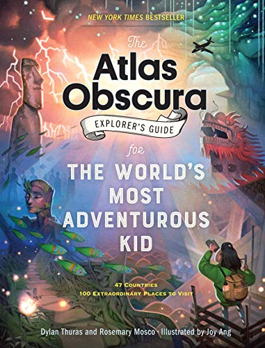
This New York Times bestseller is a thrilling expedition to 100 of the world’s most surprising, mysterious, and weird-but-true places, offering a “delectable sampler of wonders” (Kirkus) perfect for any curious kid fascinated by science, geography, and adventure.Embark on the journey of a lifetime—and see how faraway places have more in common than you might expect! Hopscotch from country to country in a chain of connecting attractions: Explore Mexico’s glittering cave of crystals, then visit the world’s largest cave in Vietnam. Peer over a 355-foot waterfall in Zambia, then learn how Antarctica’s Blood Falls got their mysterious color. Or see mysterious mummies in Japan and France, then majestic ice caves in both Argentina and Austria. As you climb mountains, zip-line over forests, and dive into oceans, this book is your passport to a world of hidden wonders, illuminated by gorgeous art.

Explore the world around you with this engaging collection of maps designed especially for middle schoolers.The latest edition of Merriam-Webster’s Student Atlas has been updated to reflect recent global events and features abundant full-color physical, political, and thematic maps. Discover the world’s landforms and bodies of water, the highest and lowest elevations, and learn more about ocean currents, and wind patterns. Thematic maps cover diverse topics such as continental drift, ocean floor, climate, natural resources, and population density. Features up-to-date statistics and global information.Packed with photographs and easy-to-use charts and graphs and featuring a glossary with brief definitions, this book is the perfect resource for kids interested in exploring the world around them both at home and in the classroom.

Who’s ready for a round-the-world trip of epic dinosaur proportions? Pack your bags, and let’s go!On this adventure, you’ll travel back in time to see more than 40 dinosaurs come to life! The geography book for kids explores each continent, revealing fossil sites and stories on every map.A unique children’s atlas that brings weird and wonderful prehistoric animals into your living room! It includes:• Each chapter explores a continent, showing where dinosaurs appeared at a given time.• Connects each dinosaur to a period ― Triassic, Jurassic or Cretaceous.• Specially commissioned maps and 3D locator globes link the prehistoric world to the present-day.• Stunning double-page spreads show dinosaurs and other prehistoric animals in dynamic scenes.• Perfect for children ages 9 and up who want to know more about dinosaurs, ice age animals and other prehistoric creatures.• A face-to-face experience with fearsome dinosaurs!Inside the pages of this children’s educational book, you’ll get to stare down a T-Rex in North America, watch out for Velociraptors' slashing claws in the Gobi Desert and trek across the Siberian tundra! You’ll also discover the answers to fascinating questions about dinosaurs. Which plant-eater weighed as much as five elephants? Where was mighty Tyrannosaurus the ultimate hunter?Using specially commissioned maps, the dinosaur atlas for kids reveal the prehistoric world as never before! A modern 3D globe next to each map helps you understand the arrangement of the continents over time and why paleontologists find fossils where they do. The fully updated edition includes the most up-to-date theories and discoveries of dinosaur science, alongside stunning CGI illustrations and maps of all the major fossil sites around the world.Dinosaur and Other Prehistoric Creatures Atlas is so much more than just a book filled with cool maps, stats and fun facts for kids, it’s also a vital source of learning ― perfect for children to dip into for school projects! Look out for more titles in this series from DK. Discover planet Earth as you've never seen it before in What's Where on Earth?

Take a tour of the United Kingdom as you’ve never seen it before in this fully illustrated set of county maps.Travel through England, Northern Ireland, Scotland and Wales and meet the incredible people born there, learn about the UK’s proud history and discover ancient castles, modern feats of engineering and natural highlights.Revel in the nation’s curiosities, from the spectacular, to the quirky, to the downright strange! Visit Edinburgh Castle with its spectacular views of Scotland’s capital; see the home of Roald Dahl in Wales; and why not sample the local delicacies at Wigan’s World Pie-Eating Championship?With colourful maps packed with facts about every inch of this Sceptred Isle, from Land’s End to John O’Groats, London to Londonderry, this book makes the perfect companion on long car journeys, summer holidays or rainy Sundays.As well as acting as your go-to guide to things to see and do, Maps of the UK is also a beautiful atlas of the UK’s history and culture, showing how Britons from all over the world have shaped the country for thousands of years.A fabulous introduction to the UK’s geography, history and culture, for readers young and old.

In this one-of-a-kind atlas, scores of archival maps and dozens of newly created maps trace the battles, political turmoil, and great themes of America's most violent and pivotal clash of arms. From the Antebellum South to Fort Sumter, the assassination of Abraham Lincoln, and the fitful peace of Reconstruction, National Geographic's Atlas of the Civil War displays eye-opening maps--and a gripping, self-contained story--on every spread.Eighty-five rare period maps, many seen here for the first time, offer the cartographic history of a land at war with itself: from 19th-century campaign maps surveying whole regions and strategies to vintage battlefield charts used by Union and Confederate generals alike, along with commercial maps produced for a news-hungry public, and comprehensive Theater of War maps. In 35 innovative views created especially for this book, the key moments of major battles are pinpointed by National Geographic's award-winning cartographers using satellite data to render the terrain with astonishing detail.In addition, more than 320 documentary photographs, battlefield sketches, paintings, and artifacts bear eyewitness testimony to the war, history's first to be widely captured on film.

Rand McNally's Atlas of World Geography provides engaging and richly illustrated geographic information for secondary students from grades 6-12.Thematic maps, graphs and charts help present a more complete portrait of our physical and political world.Atlas of World Geography features:85 pages of detailed physical and political mapsEngaging illustrations, photography, and infographics35 pages of human and physical world geography maps, graphs, charts, including information on plate tectonics, climate, environments, population and economicsUpdated Countries section including flag, capital city, area and populationGlossary of foreign terminology plus comprehensive index to enrich and maximize use of mapsSpecial continent sections exploring landforms, land cover and use, climate, and continent specific issues and current events

The new fifth edition of National Geographic's award-winning atlas is more fascinating and fact-filled than ever! It's the definitive atlas for middle and high-school students to explore and use in the classroom, college prep, and at home.From the cartographic experts at National Geographic comes the latest edition of its award-winning student atlas, with everything kids want and need to know about our changing world. Dynamic, user-friendly content includes photos, facts, charts, graphics, and full-color political, physical, and thematic maps on important topics. Completely updated maps and statistics ensure that kids have all the latest information as they learn more about current events and become global citizens.

How To Draw Illustrated Maps takes a highly visual and practical approach to drawing, featuring step-by-step instructions for each art project. This comprehensive drawing handbook covers all aspects of drawing a wide variety of different illustrated maps, from fantasy landscapes to modern metropolises, including essential concepts such as scale and composition.
From the team behind the best-selling Atlas of Adventures comes this awe-inspiring journey of discovery. Travel around the world to scale the Eiffel Tower, trek the Great Wall of China, and raft through the Yosemite Valley. Showcasing the globe's most impressive landscapes, iconic buildings and evocative antiquities from both the modern and ancient worlds, this is the most wonderful Atlas adventure yet!

Inspired by Rand McNally's award-winning Classroom Atlas, World Atlas for grades 4-9 is packed with maps, photos, infographics, critical-thinking questions, and brain teasers designed to reinforce and further develop map skills, as well as build global competency.
Know Geography for grades 9-12 presents a more complete portrait of our physical and political world. Featuring the same engaging and richly illustrated geographic information from Rand McNally's award-winning Atlas of World Geography, this book includes a glossary of foreign terminology, an update countries section with national flags, and comprehensive continents sections.

Step into the realms of the gods, in this spectacular exploration of the myths and legends of the world. Meet the gods and heroes; the villians, tricksters and fantastical beasts of twelve major mythologies, including Egyptian, Greek, Japanese, Native American, Norse, Polynesian and Aztec. With its brilliantly imagined 'maps' of each mythological world, plus a wealth of stories, facts, detail and humour, Myth Atlas is a magnificent gift book which will captivate children and adults alike.

Hold the world in your hands with the Travel Book, full of fantastic info about every country on EarthHold the world in your hands with The Travel Book - full of fantastic facts and incredible info about every single country in the world.With a new country on every page, this is a roller-coaster ride around our amazing planet.A mix of beautiful illustrations and stunning photography brings each land to life.

The natural world has never been wilder―with 100 fiercely fun, curiously captivating, and amazingly adventurous maps Which nations have launched animals into space? Where are the world’s cat people? How many humans live in high-risk zones for natural disasters? How far do you have to travel to hug all fifteen of the world’s oldest trees? Where in the world do snakes live―or better yet, where can you avoid them?! Find the thought-provoking answers to these questions and many more in Wild Maps for Curious Minds. This infographic atlas of nature’s most impressive wonders and eye-popping oddities is bursting with discovery (Where’s the most remote place on Earth?), whimsical insight (Which animals have launched into space?), and startling revelations (How much forest have we destroyed?) that will change the way you see the natural world―and that celebrate our planet and the plants and animals with whom we share it. 100 color maps

The joys of the world, one terrible map at a time – this is the ultimate gift book for the budding geographer or anyone who wants to have a laugh.Ever wondered about the average jean colour across the United States? Or what ‘pedestrians’ look like in Denmark? What unites Brokenwind, Upton Snodsbury and Crackpot? And have you ever tried to take a train in Antarctica? Well Terrible Maps is the book for you!Put together by the creator behind the tremendously popular social media feed, this is the ultimate humour book for the budding geographer in your life. From countries that eat their national animals to nations that have declared war on birds (and lost), Terrible Maps celebrates pointless cartography in all its glory. Don’t leave home without it!

BRAND NEW, Exactly same ISBN as listed, Please double check ISBN carefully before ordering.

The story behind the world's fl agsFrom national flags and coats of arms to the feared pirate skull and crossbones, all flags are pictures with a special meaning for those in the know! In The Flag Book we explore a fascinating world of colours, images and symbols, and reveal lots of amazing facts about every country's flag and what it represents.A fascinating and visually engaging way to learn about other countriesCombines photos and illustrationsIncludes national, state, and ship and aeroplane flags

The first book of its kind, this stunning atlas showcases America's spectacular park system from coast to coast, richly illustrated with an inspiring and informative collection of maps, graphics, and photographs.From the white sand beaches of Dry Tortugas to the snowy peaks of Denali, this captivating book combines authoritative park maps with hundreds of graphics and photographs to tell the stories of America's sixty one beloved national parks. Former ranger and author Jonathan Waterman introduces readers to the country's scenic reserves and highlights the extraordinary features that distinguish each: magnificent landmarks, thriving ecosystems, representative wildlife, fascinating histories, and more. With striking imagery and state-of-the-art graphics reflecting details of wildlife, climate, culture, archaeology, recreation, and more, this lush reference provides an up-close look at what makes these lands so special--and so uniquely American. A heartfelt foreword from National Geographic CEO Gary Knell reminds us how important these lands are to our lives and our national pride.

Set your spirit of adventure free with this journey to the world’s great oceans, discovering the diversity of life that exists in the deep blue sea. Whether you’re travelling long haul with leatherback turtles across the Pacific, snoozing with sea otters or ice bathing with a walrus, this book celebrates the very prescient topic of the world’s oceans with Lucy Letherland’s animal characters. A natural history lesson in an adventure book, each spread features 10 captions and and facts about every destination. The 5th title in the best-selling Atlas of Adventures series that has now been translated into 31 languages.

WINNER, Edward Stanford Travel Writing Awards 2022: Illustrated Travel Book of the Year. HIGHLY COMMENDED, British Cartographic Society Awards 2022.From Stephen King’s Salem’s Lot to the superhero land of Wakanda, from Lilliput of Gulliver's Travels to Springfield in The Simpsons, this is a wondrous atlas of imagined places around the world. Locations from film, tv, literature, myths, comics and video games are plotted in a series of beautiful vintage-looking maps.The maps feature fictional buildings, towns, cities and countries plus mountains and rivers, oceans and seas. Ever wondered where the Bates Motel was based? Or Bedford Falls in It's a Wonderful Life? The authors have taken years to research the likely geography of thousands of popular culture locations that have become almost real to us. Sometimes these are easy to work out, but other times a bit of detective work is needed and the authors have been those detectives. By looking at the maps, you'll find that the revolution at Animal Farm happened next to Winnie the Pooh's home.Each location has an an extended index entry plus coordinates so you can find it on the maps. Illuminating essays accompanying the maps give a great insight into the stories behind the imaginary places, from Harry Potter's wizardry to Stone Age Bedrock in the Flintstones.A stunning map collection of invented geography and topography drawn from the world’s imagination. Fascinating and beautiful, this is an essential book for any popular culture fan and map enthusiast.

The must-have Back to School Atlas for Year 6Fully revised and updated, this is an ideal world reference atlas for young primary school geographers aged 8-11 years (Key stage 2). Published in association with the Geographical Association, it enables ch

A fascinating and surprising history of the world told through the lines people have drawn on mapsPeople have been drawing lines on maps for as long as there have been maps to draw on. Sometimes rooted in physical geography, sometimes entirely arbitrary, these lines might often have looked very different if a war or treaty or the decisions of a handful of tired Europeans had gone a different way. By telling the stories of these borders, we can learn a lot about how political identities are shaped, why the world looks the way it does―and about human folly.From the Roman attempts to define the boundaries of civilization, to the secret British-French agreement to carve up the Ottoman Empire during the First World War, to the reason why landlocked Bolivia still maintains a navy, this is a fascinating, witty, and surprising look at the history of the world told through its borders. 22 Black & White Maps

"This is such a great book for primary school age children and a little beyond for finding out about the world, its countries and people" Amazon customer review- Philip's atlas, designed specially to use at home and at school with guidance for parents and teachers- Clear maps and fascinating facts bring geography to life for readers aged 7-12- Published by Philip's the UK's leading school atlas publisher, in association with the Royal Geographical Society- Quizzes, activity ideas and puzzles to make learning fun- Past winner of the Geographical Association's award for making a significant contribution to geographyThe atlas is organized spread by spread in the classic sequence: first Europe, then its land neighbour Asia, followed by Africa, Australia and Oceania, North America and South America.Illustrated with captivating full-colour photographs and packed with fact boxes, curiosities, flags, stamps and quiz questions, Philip's RGS Children's Atlas is both fun to use and easy to understand.Now in its 16th edition, Philip's RGS Children's Atlas is a past winner of the Geographical Association's award for making a significant contribution to geography. The atlas was judged "an excellent 'all round' children's atlas with simple yet well-designed maps, well-illustrated with colour photographs. It links places to issues, events and real people, giving a clear sense of place."

You will be hard-pressed to find a more impressive children's atlas than this one! Tour the world on a 3D action-packed journey of fun fact discovery.Earth is brought to life like never before through stunning, specially commissioned 3D maps and artworks. Uncover incredible geographical features, wildlife, cities and landmarks, and the world's population in unprecedented detail.If you are looking for adventure, look no further. Scale the majestic peaks of the Himalayas, trek through the thick, creature filled jungles of South America, or roam the expansive grasslands of Africa in these pages!This amazing educational book is so much more than just a knowledge book filled with cool maps and facts about the world. This vital source of learning is perfect for children to dip into for school projects and is a fantastic addition to any family library.Explore, Learn And Get To Know The World Around You In Spectacular Detail!See the world like never before. More than 60 stunning, specially commissioned maps take you on a fact-filled continent-by-continent tour of the world you will never forget!Without even leaving your home, this awesome kid's educational book allows you-Go back in time to see how the continents have evolved-See incredible geographical features-Learn about fascinating animals the world over-Travel the world's cities and landmarks-Dive into intriguing facts about the world's populationA kid's atlas that makes the perfect gift and home reference for any child ages 8 to 11 with an interest in the world around them and a taste for adventure!Part of the bestselling Where on Earth? series including titles such as What's Where on Earth? - Dinosaurs and Other Prehistoric Life , When on Earth? - History As You've Never Seen It Before! , and more.

Explore the animal kingdom with this pictorial atlas of the world's wildlife.Where do animals build their homes? How do they survive in very hot and cold climates? Why are so many species endangered? Discover the answers to all these questions and many more in The Animal Atlas. This lavishly illustrated nature book takes children on a tour, continent by continent, to meet the animals of the world. Within each section, the book travels through different biomes, such as forests, deserts, and lakes; and specific regions, from the Everglades to the Galapagos, Himalayas, and Great Barrier Reef.The Animal Atlas is packed with beautiful, life-like illustrations of mammals, birds, reptiles, amphibians, and insects that live all around the world, from the Amazon to Antarctica. Each species is carefully hand-drawn to show details of fur, feathers, or scales, while accompanying captions reveal fascinating facts about the animal's behaviour.Maps, along with icons to represent each animal, show precisely where the animals are found. For example, Australia's iconic koala can be tracked down to the east coast of the country.The book starts with an introduction to animal groups and habitats, and finishes with endangered species and a gallery of amazing, record-breaking animals. First published in 1992, this atlas has been updated for the 2020 edition and is a beautiful gift for a new generation of zoologists.


The ‘Introducing Atlas Maps’ section – useful for both teacher and pupil – is followed by clear, easy-to-read reference maps. An extended ‘World’ section covers global issues such as population, climate change and environmental issues.• Encourages development of map, atlas and data handling skills• Ideal for classroom use or home learning• Fully up-to-date• Suitable for ages 11-14Reference maps include:• Locator maps• Fact boxes• Flags• Descriptive text• Detailed map keys• Photos• Focus country studiesThe next atlas in the series is the Collins Student Atlas (ISBN 9780008430238).

An Atlas Of Afterlives Is A Haunting And Darkly Intriguing Take On World Myth, Giving Readers A Glimpse At What Lies Beyond.

Are YOU the ultimate map-reader?Do you know your trig points from your National Trails? Can you calculate using contours? And can you fathom exactly how far the footpath is from the free house?Track down hidden treasures, decipher geographical details and discover amazing facts as you work through this unique puzzle book based on 40 of the Ordnance Survey's best British maps. Explore the first ever OS map made in 1801, unearth the history of curious place names, encounter abandoned Medieval villages and search the site of the first tarmac road in the world.With hundreds of puzzles ranging from easy to mind-boggling, this mix of navigational tests, word games, code-crackers, anagrams and mathematical conundrums will put your friends and family through their paces on the path to becoming the ultimate map-master!

The world of contemporary mapmaking is brought up-to-date in this revised and expanded edition of a best-selling book.For centuries we have used the tools of cartography to represent both our immediate surroundings and the world at large—and to convey them to others. In our age of satellite navigation systems and Google Maps, personal interpretations of the geography around us are becoming even more relevant. A new generation of designers, illustrators, and mapmakers have been discovering their passion for various forms of illustrative cartography and A Map of the World is a compelling collection of their work. This updated edition contains even more examples of their output, ranging from detailed representations to personal, naive, and contemporary interpretations.